|
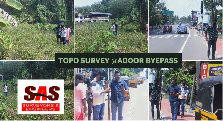
Topo survey @adoor byepass - Road Survy from SAS Surveyors & Engineers in Pathanamthitta
 Views : 73697 Views : 73697
Topo survey @adoor byepass - Road Survy from SAS Surveyors & Engineers in PathanamthittaLand Surveyors in Pathanamthitta, Land Surveyors in Thiruvalla, Land Surveyors in Adoor, Land Surveyors in Pandalam, Land Surveyors in Kozhencherry, Land Surveyors in Pathanamthitta - SAS Surveyors & Engineers in Pathanamthitta. Land surveying, Surveyor, Geomatics,Boundary survey, Topographic survey, Construction survey, GPS surveying, Land measurement, Land mapping, Geodetic survey, Surveying equipment, Legal descriptions, Land records, Geographic information system (GIS), Land development, Cadastral survey, Elevation survey, Remote sensing, Aerial surveying, Geospatial data
|
|
|
|
|
Digital Land Survey Consultant & Plotting Centre
 Views : 69866 Views : 69866
Digital land survey refers to the modernized process of capturing, analyzing, and presenting geospatial data related to land boundaries and features using advanced digital technologies. It involves the use of various tools such as satellite imagery, GPS (Global Positioning System), and Geographic Information Systems (GIS) to accurately measure and map land parcels.
Geospatial data, Land boundaries, Satellite imagery, GPS (Global Positioning System), Geographic Information Systems (GIS), Accuracy, Efficiency, Data management, Precise measurements, Automation, Data integration, Real-time positioning, Topographic information, Urban planning, Infrastructure development, Land management, Data analysis, Collaboration, Data sharing, Resource management
|
|
|
|
|
Land Title Survey
 Views : 69295 Views : 69295
Land Title Survey in Idukki, Kottayam, Pathanamthitta, Kerala
There are several different types of land surveying, each serving specific purposes and applications. Here are some common types of land surveying: Land surveying, Surveyor, Geomatics, Boundary survey, Topographic survey, Construction survey, GPS surveying, Land measurement, Land mapping, Geodetic survey, Surveying equipment, Legal descriptions, Land records, Geographic information system (GIS), Land development, Cadastral survey, Elevation survey, Remote sensing, Aerial surveying, Geospatial data
|
|
|
|
|
On-Campus Training Program in South India- SAS Surveyors & Engineers
 Views : 50350 Views : 50350
Survey design, Data collection, Data analysis, Survey ethics, Survey research methods, Survey software
Land surveying, Surveyor, Geomatics, Boundary survey, Topographic survey, Construction survey, GPS surveying, Land measurement, Land mapping, Geodetic survey, Surveying equipment, Legal descriptions, Land records, Geographic information system (GIS), Land development, Cadastral survey, Elevation survey, Remote sensing, Aerial surveying, Geospatial data
|
|
|
|
|
Advanced Land Survey Training - Kottayam- SAS Surveyors & Engineers
 Views : 50736 Views : 50736
Preliminary Survey, Land surveying, Surveying, Geomatics, Geospatial engineering, Cartography, Topography
Cadastral surveying, Boundary surveying, Construction surveying, Engineering surveying, Land development
Real estate, Property, Maps, Plats, GIS
|
|
|
|
|
|
|
Land Mapping Masters - SAS Surveyors & Engineers - Pathanamthitta - Kerala
 Views : 53513 Views : 53513
Land surveyors are skilled professionals responsible for measuring and mapping land areas to ensure accurate property boundaries and legal descriptions. Using advanced surveying instruments and techniques, they collect and analyze data to create detailed maps, identify topographic features, and establish reference points. These dedicated experts play a crucial role in various industries such as construction, real estate, infrastructure development, and land management. With their precise measurements and comprehensive knowledge, land surveyors contribute to the efficient planning, design, and utilization of land resources while ensuring compliance with regulatory requirements.
Land surveying, Surveyor, Geomatics, Boundary survey, Topographic survey, Construction survey, GPS surveying, Land measurement, Land mapping, Geodetic survey, Surveying equipment, Legal descriptions, Land records, Geographic information system (GIS), Land development, Cadastral survey, Elevation survey, Remote sensing, Aerial surveying, Geospatial data
|
|
|
Land Surveyors in Kottayam
 Views : 63347 Views : 63347
We, Sas Surveyors And Engineers, One of the branch at Kottayam, Kerala are a professional land surveying firm specializing in surveying & mapping of infrastructure, residential, industrial projects & layout services.
Land surveying, Surveyor, Geomatics, Boundary survey, Topographic survey, Construction survey, GPS surveying, Land measurement, Land mapping, Geodetic survey, Surveying equipment, Legal descriptions, Land records, Geographic information system (GIS), Land development, Cadastral survey, Elevation survey, Remote sensing, Aerial surveying, Geospatial data
|
|
|
|
|
|
|
traffic survey kerala, digital survey kollam, digital survey, drone survey kerala, aerial survey kerala, UAV kerala, traffic data analysis, traffic flow analysis, traffic congestion analysis, road traffic survey, vehicle count survey, speed survey, traffic volume survey, digital mapping, geographic - Sas Surveyors And Engineers offers comprehensive land surveying and mapping services for infrastructure, residential, and industrial projects in Pathanamthitta, Pala, Kottayam, Alappuzha, Idukki, and Ernakulam. Our expertise includes road surveys, GPS surveys, geological surveys, and more. View Ocatlink of SAS Surveyors & Engineers
Listed in :
Road Surveyors and Engineers in Kerala |
Digital Land Survey Consultant & Plotting Centre in Kerala |
Quality Geotechnical Services In Kerala |
Survey Solutions & Road Survey Services In Kerala |
|
|